
Hiking in and around Bad Arolsen
A network of about 300 km of marked hiking routes

Guided hikes with knowledgeable, local guides
On the third Saturdays of each month at 14.00, a free hike is offered that is guided by a knowledgeable guide and that explores the beautiful woods and landscapes and of course Twistesee lake.
Meeting point for these hikes:
Touristik-Service, Große Allee 24
The hikers and the guide together select a route that matches their personal preferences for difficulty and length (hikes are typically about 8 m).
Hiking routes for independent hikers
For a first impression of the 400-km hiking route network in and around Bad Arolsen, you can take a look at the hiking map here.
The hiking map with a built-in map of the city is available for sale at the Touristik-Service centre.
Note: The trail markers are based on the different suburbs of Bad Arolsen. For example, H1 stands for a hiking trail in Helsen, and K2 for a hiking trail in Kohlgrund.
Enjoy making your plans!
Examples for two hiking routes
Circular hiking route from Bad Arolsen to Mengeringhausen (1783 KB)
25.05.2020 08:15Uhr,Circular hiking route from Bad Arolsen to Twistesee (90 KB)
25.05.2020 08:23Uhr,
More topics
31.08.2018 Cycling in and around Bad Arolsen
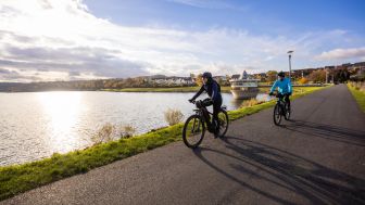
Bad Arolsen is also a great place to go on a long bicycle ride.
Details ansehen
Contact
Große Allee 24
34454 Bad Arolsen
Anschrift
Stadt Bad Arolsen
- Der Magistrat -
Große Allee 24
34454 Bad Arolsen